
Tiedosto:AMH-6328-KB Map of a stretch of the West African coast.jpg
Alkuperäinen tiedosto (2 400 × 1 961 kuvapistettä, 761 KiB, MIME-tyyppi: image/jpeg)
Yhteenveto
Nederlands: Kaart van een gedeelte van de West-Afrikaanse kust
English: Map of a stretch of the West African coast( |
|||||||||||||||||||||||||||||||||||||||||||||
|---|---|---|---|---|---|---|---|---|---|---|---|---|---|---|---|---|---|---|---|---|---|---|---|---|---|---|---|---|---|---|---|---|---|---|---|---|---|---|---|---|---|---|---|---|---|
| Tekijä |
Nederlands: Jacobus van der Schley (direxit), Pierre d' Hondt (uitgever)
English: Jacobus van der Schley (direxit), Pierre d' Hondt (publisher) |
||||||||||||||||||||||||||||||||||||||||||||
| Otsikko |
Nederlands: Kaart van een gedeelte van de West-Afrikaanse kust
English: Map of a stretch of the West African coast |
||||||||||||||||||||||||||||||||||||||||||||
| Kuvaus |
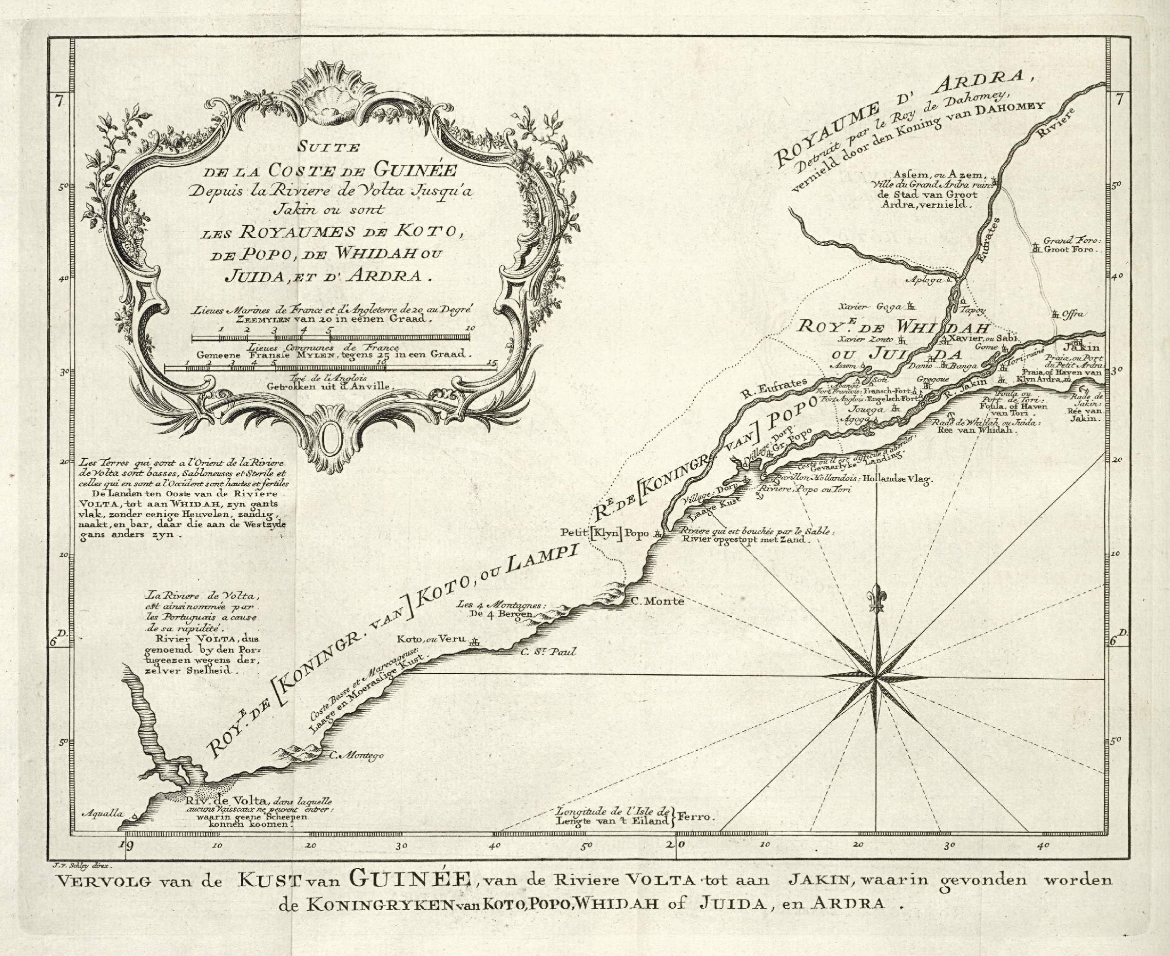
Nederlands: Kaart van een gedeelte van de West-Afrikaanse kust.
Vervolg van de Kust van Guinée, van de Riviere Volta tot aan Jakin, waarin gevonden worden de Koningryken van Koto, Popo, Whidah of Juida, en Ardra. Suite de la Coste de Guinée Depuis la Riviere de Volta Jusqu'a Jakin ou sont les Royaumes de Koto, de Popo, de Whidah ou Juida, et d'Ardra.English: Map of a stretch of the West African coast.
Vervolg van de Kust van Guinée, van de Riviere Volta tot aan Jakin, waarin gevonden worden de Koningryken van Koto, Popo, Whidah of Juida, en Ardra. Suite de la Coste de Guinée Depuis la Riviere de Volta Jusqu'a Jakin ou sont les Royaumes de Koto, de Popo, de Whidah ou Juida, et d'Ardra. |
||||||||||||||||||||||||||||||||||||||||||||
| Päiväys | 1747 | ||||||||||||||||||||||||||||||||||||||||||||
| Tekniikka |
Nederlands: gravure op papier
English: engraving on paper |
||||||||||||||||||||||||||||||||||||||||||||
| Mitat | korkeus: 20 cm; leveys: 16,5 cm | ||||||||||||||||||||||||||||||||||||||||||||
| Kokoelma |
|
||||||||||||||||||||||||||||||||||||||||||||
| Tunniste |
693 C 6 dl. V na p. 355 |
||||||||||||||||||||||||||||||||||||||||||||
| Merkinnät |
Vervolg van de Kust van Guinée, van de Riviere Volta tot aan Jakin
author: J. v. Schley direx. |
||||||||||||||||||||||||||||||||||||||||||||
| Lisätietoja |
English: Subjects: chart / map / plan, compass / dial, banderole / cartouche / ornamentation
Nederlands: Onderwerpen: plattegrond / kaart, kompas / windroos, banderol / cartouche / versiering
English: Post: this image is related to a WIC trading post called Aneho |
||||||||||||||||||||||||||||||||||||||||||||
| Lähde/Valokuvaaja |
|
||||||||||||||||||||||||||||||||||||||||||||
| Käyttöoikeus (Tämän tiedoston uudelleenkäyttö) |
|
||||||||||||||||||||||||||||||||||||||||||||

| Kohteen sijainti | | Tämä ja muut kuvat kartalla: OpenStreetMap |
|---|
Tiedoston historia
Päiväystä napsauttamalla näet, millainen tiedosto oli kyseisellä hetkellä.
| Päiväys | Pienoiskuva | Koko | Käyttäjä | Kommentti | |
|---|---|---|---|---|---|
| nykyinen | 10. kesäkuuta 2014 kello 11.02 | | 2 400 × 1 961 (761 KiB) | HuskyBot | == {{int:filedesc}} == {{Artwork |title = {{nl|1=Kaart van een gedeelte van de West-Afrikaanse kust}} {{en|1=Map of a stretch of the West African coast}} |description = {{nl|1=Kaart van een gedeelte van de West... |
Tiedoston käyttö
Seuraava sivu käyttää tätä tiedostoa:
Tiedoston järjestelmänlaajuinen käyttö
Seuraavat muut wikit käyttävät tätä tiedostoa:
- Käyttö kohteessa fi.wikipedia.org