
Tiedosto:Road network around the Pueblo Alto community.png

Tämän esikatselun koko: 800 × 576 kuvapistettä. Muut resoluutiot: 320 × 231 kuvapistettä | 640 × 461 kuvapistettä | 1 024 × 738 kuvapistettä | 1 234 × 889 kuvapistettä.
Alkuperäinen tiedosto (1 234 × 889 kuvapistettä, 238 KiB, MIME-tyyppi: image/png)
Yhteenveto
| Kuvaus |
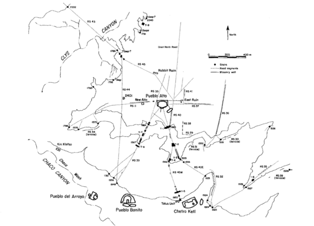
English: A National Park Service map of the road network around the Pueblo Alto community. |
| Päiväys | |
| Lähde | Culture and Ecology of Chaco Canyon and the San Juan Basin. Publications in Archeology 18H, Chaco Canyon Studies. National Park Service, Santa Fe, 2005, by Mathien, Frances Joan; page 153. |
| Tekijä | National Park Service |
Lisenssi
| This image or media file contains material based on a work of a National Park Service employee, created as part of that person's official duties. As a work of the U.S. federal government, such work is in the public domain in the United States. See the NPS website and NPS copyright policy for more information. |
Tiedoston historia
Päiväystä napsauttamalla näet, millainen tiedosto oli kyseisellä hetkellä.
| Päiväys | Pienoiskuva | Koko | Käyttäjä | Kommentti | |
|---|---|---|---|---|---|
| nykyinen | 20. toukokuuta 2015 kello 19.11 | | 1 234 × 889 (238 KiB) | Rationalobserver | User created page with UploadWizard |
Tiedoston käyttö
Seuraava sivu käyttää tätä tiedostoa:
Tiedoston järjestelmänlaajuinen käyttö
Seuraavat muut wikit käyttävät tätä tiedostoa:
- Käyttö kohteessa en.wikipedia.org